Basic navigation
After you have installed GeoAdministrator, the GeoAdministrator tab is shown on the ribbon in ArcGIS Pro.
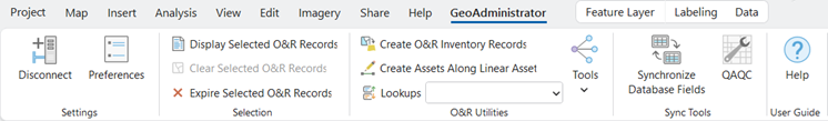
This table describes the buttons on the GeoAdministrator tab:
| Button | Description |
|---|---|
| Connect/Disconnect | Logs in to the Operations and Regulations database. You must specify a valid user name and password. |
| Preferences | Shows the preferences dialog box, which manages system preferences such as field mappings, QAQC settings, and logging.
See Setting preferences. |
| Display Selected O&R Records | Shows the records in the Operations and Regulations database that correspond to one or more selected map features, such as an address record or an asset inventory record. The information is displayed in the appropriate Infor Operations and Regulations InfoViewer. |
| Clear Selected O&R Records | Clears the selected features on the map. |
| Expire Selected O&R Records | Expires selected records in Operations and Regulations and optionally deletes their map features. |
| Create O&R Inventory Records | Creates new records in the Operations and Regulations database for selected map features, such as creating an asset inventory record for an existing asset on the map.
See Create records. |
| Create Assets Along Linear Asset | Creates a new asset at a specified location along a selected linear asset. |
| Lookups | Used to search for Operations and Regulations records and show them on the map. |
| Tools | The menu includes these options:
|
| Synchronize Database Fields | Synchronizes data between the Operations and Regulations database and the geodatabase.
See Synchronizing data. |
| QAQC | GeoAdministrator’s QAQC tool. Compares records in the Operations and Regulations database and the geodatabase to ensure that all data is consistent.
See QAQC. |
| Help | Shows the GeoAdministrator help |
Create Features
GeoAdministrator also adds buttons to the pane, which is shown when you click on the tab in ArcGIS Pro.
A button is shown on each layer in the pane that corresponds to a type of record in Operations and Regulations. For example, the button is shown when you select an address layer.
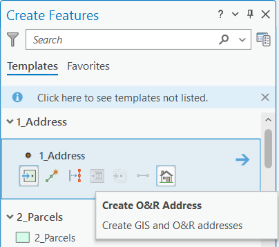
See Create records.