Altering the start of a roadway

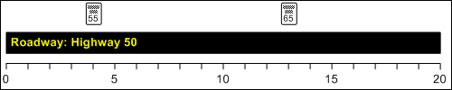
You can change the starting measurement of a roadway without adding or removing any length. Roadways typically start at 0.00, whichever unit of measure is used, but this isn’t required. For example, this diagram shows a roadway that runs from 0 miles to 20 miles, with signs 4 miles and 13 miles from the start.

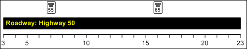
The diagram below shows what happens if the roadway start is changed to 3 miles. Because you’re increasing the starting measurement by 3 miles, Infor Public Sector adds 3 miles to all measurements along the roadway. Thus, the signs are now at 7 miles and 16 miles.

  1. Select Asset Management > Assets > Roadway.
  2. On the Roadway tab, under Configuration, click Alter Roadway Start Tool.
  3. Specify this information:
    Roadway
    Specify the ID of the roadway being altered.
    Starting From
    Specify the new starting measurement for the roadway.
    Maintain Roadway History
    Select to maintain a record of the roadway structure before the change. A record is added to the RWTOOLHIST (RoadwayToolHistory) table, indicating the roadway ID and the new starting and ending measurements. You can then view a history of the roadway and the affected roadway data in the Roadway InfoViewer.
  4. Click Finish.
    Infor Public Sector updates the starting measurement of the roadway and adjusts all other measurements along the roadway accordingly. Infor Public Sector also adds roadway history records for all affected work orders, inspections, and service requests. Because these records represent historical events rather than roadway characteristics, their measurements aren’t adjusted. You can view roadway history data on the Roadway History tab of the appropriate InfoViewer.