Adding length to a roadway
To add length to a roadway, specify the location of the added length, measured from the start of the roadway, and the amount of length to add. In the simplest case, length is added at the start or end of a roadway.
If you add length at the start of the roadway, the amount of length is added to the measurements of all items attached to the roadway. For example, this diagram shows a roadway with a sign positioned 12 miles from the start. Two miles are added to the start of the roadway:
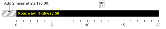
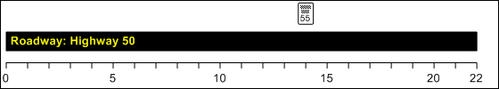
This has the effect of pushing the start of the roadway back two miles, so the sign is now located 14 miles from the start:
You can also add length in the middle of a roadway, such as adding 5 miles beginning 15 miles from the start. In this case, the measurements of all items beyond the specified location are adjusted by the added length, and measurements before the added length are unaffected.
If the location at which the length is added falls between the start and end of a range, the range is split in two. For example, suppose an attribute begins 20 miles from the start of a roadway and ends 40 miles from the start of the roadway. If you add 10 miles starting 30 miles from the start of the roadway, you will have two attributes. The first runs from 20 to 30 miles from the start of the roadway and the second runs from 40 to 50 miles from the start of the roadway. The new section of road, from 30 to 40 miles from the start, has no attribute.