Roadway tools example
This example shows a situation where you must use more than one of the roadway tools to accurately capture changes to a roadway’s structure.
This diagram represents a roadway that is to be rerouted. A new section of road will be built starting at point A, 5 miles from the start of the roadway. The new section will join the original roadway at point B, which is currently 16 miles from the start. (Note that this is merely a conceptual diagram, and it is not drawn to scale.)
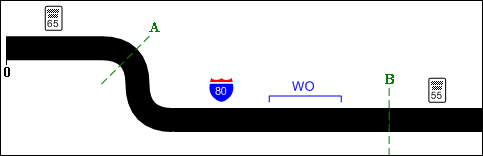
As it stands, the roadway is 20 miles long, and has three signs attached to it: a speed limit sign (65 mph) 2 miles from the start; an interstate sign 8.5 miles from the start; and another speed limit sign (55 mph) 18 miles from the start. Further, a Speed Limit attribute (65 mph) covers the range marked by the two speed limit signs, from 2 miles to 18 miles from the start. Finally, a work order was completed last year to resurface a section of the roadway beginning 10 miles from the start and ending 12 miles from the start.
This diagram represents the roadway after construction is completed:
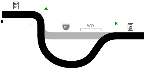
Suppose the new section is 17 miles long, where the old section it replaces was 11 miles long. (Again, the diagram is not drawn to scale.) So overall the roadway is now 6 miles longer than it was.
However, if you add 6 miles to the roadway starting at either point A or point B, the roadway data will not be accurate. For example, if you add 6 miles at point A, Infor Public Sector will add that length to the measurement of the interstate sign, giving a new measurement of 14.5 miles from the start. In reality, that sign is no longer attached to the roadway.
The first step is to use the Remove Roadway Length tool to remove 11 miles starting at point A. Thus, you’re removing a section starting 5 miles from the start and ending 16 miles from the start. This affects the roadway data as follows:
- The first speed limit sign, which is located before the start of the removed length, is unaffected.
- The Speed Limit attribute, which spans the entire section being removed, has 11 miles subtracted from its ending measurement. It now runs form 2 miles from the start to 7 miles from the start.
- The interstate sign, which falls within the removed length, is expired.
- The work order is a historical record, indicating work that was done on the disused section of road, so Infor Public Sector adds a roadway history record to reflect this.
- The second speed limit sign, which is beyond the removed section, has the removed length subtracted from its measurement, giving a new value of 7 miles from the start.
After the disused section is removed, you can use the Add Roadway Length tool to add the new section of 17 miles starting at point A. Again, the first speed limit sign is unaffected. The second speed limit sign has 17 miles added to its measurement, giving a new value of 24 miles from the start.
The added length falls between the start and end of the Speed Limit attribute, so this attribute is split in two. The first of the two new attributes runs from 2 miles to 5 miles from the start of the roadway. The second runs from 22 miles to 24 miles from the start of the roadway. The new section of road has no speed limit attribute, so you must add it manually.