Territory Planning Workbench (tsspc8351m000)
Use this session to view and maintain the generated territory planning. It is also possible to compare a territory planning with actual or compare two territory planning.
The territory planning functionality enables you to perform territory and preferred engineer simulations. The objective is to reduce travel by clustering the interchangeable work in geographical areas. The territory engine compares the required capacity for the serials, with the available capacity (the engineers or simulations engineers). The engine calculates the best possible combination of the required capacity for the serialized item and the available capacity. Optionally, an engineer can be made responsible for a territory and the optimal territories can also be calculated.
The planner select, using defined selection criteria, the serialized items that are to be serviced (required capacity) in a certain geographical area. The system calculates the required capacity on historical and/or already known data. To check the available capacity, the user can specify existing service engineers, as well as simulation engineers, for maximum flexibility. If the calendar and availability type of an engineer is defined, the system calculates the available capacity. The user can use the simulation results, to modify the preferred engineer on the serialized item and/or the territory.
The following option are available: 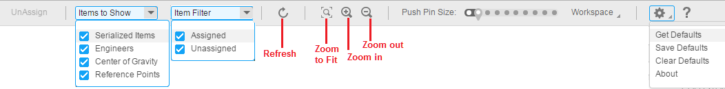
- Unassign : Un-assigns the engineer from the selected serialized item. This button is enabled:
- When a serialized item(s) is selected which is already assigned to an engineer.
- When the selection does not contain items from both Plan A and Plan B
- Items to show: This includes a list of map layers. When you select/unselect an item, the item hides/shows the respective layer on the map. By default, all the layers are selected. Item Filter: This value can be set to Assigned and/or Unassigned. By default both Assigned and Unassigned are selected. When the user unselects an item, for example Assigned, only the unassigned items are visible on the workbench (on map and also on Grid).
- Refresh: Refresh the data for the selected territory plan(s).
- Zoom To Fit: This zooms the map to the optimum level, so that all the serial items on the map are visible.
- Zoom in, Zoom out : This is used to zoom in and out to the engineer on the map.
- Pushpins size: This is used to increase and decrease the size of the pushpins on the map.
- Workspace Menu: This includes various menus relating to the UI layout of the workbench.
- Settings and Help: The settings menu includes options such as default/layout persistence. The help opens the online help.
The following icons are used in the territory planning workbench.
| Icon | Explanation |
|---|---|
 |
This icon represents the location of the engineer (if specified in territory planning). All the serialized items assigned to the engineer are of same colour and the icon must have color of the serialized items that are assigned to the engineer. Note This icon also displays the picture of the engineer, if available in the Employees - General (tccom0101m000) session. |
 |
This icon represents the reference point that is specified for the engineer. It should have the same color as engineer it is assigned. |
 |
This icon represents the center of gravity of the items which belong to the same territory. |
 |
This icon indicates a serialized item (or in later versions also an installation group).
|
 |
This icon represents the serialized item specified on the Plan A of the work bench, but the serialized item is not linked to a preferred engineer or territory on Plan B |
 |
This icon represents the serialized item, but only one territory planning is selected either on the Plan A or the Plan B. |