Introduction to Territory Planning Workbench
The territory planning functionality enables you to perform territory and preferred engineer simulations. The objective is to reduce travel time by clustering the interchangeable work in geographical areas.
You can select, using the defined selection criteria, the serialized items that must be serviced (required capacity) in a certain geographical area. The LN calculates the required capacity based on historical and/or known data. To check the available capacity, the user can referred to the existing service engineers, as well as engineers retrieved from the simulation process. This provides more flexibility from the planning prospective. If the calendar and availability type of an engineer is specified, the LN calculates the available capacity. The user can use the simulation results, to modify the preferred engineer for the serialized item and/or the territory.
Positioning
The Territory Planning Workbench is positioned with Service Planning modules. The modules that are part of the Service Planning are Territory Planning, Preventive Maintenance Planning, and Group Planning. The territory engine compares the required capacity for the serials, with the available capacity (the engineers or simulations engineers). The engine calculates the best possible combination of the required capacity for the serialized item and the available capacity. Optionally, an engineer can be made responsible for a territory and the optimal territories can also be calculated.
Launching the Workbench
To access workbench, you must select a plan in the Territory and Preferred Engineer Planning (tsspc4100m000) session and select the Territory Planning Workbench option. The selected plan is uploaded in the Territory Planning Workbench (tsspc8351m000) session.
Layout
Use the workbench to perform territory and preferred engineer simulations, taking into account the various constraints such as reference points, service engineer location, center of gravity, serialized item and so on.
When the workbench is accessed, all the data related to the serialized item, preferred engineer, reference points is populated.
The workbench includes these sections:
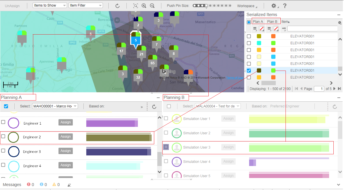
- Serialized Items : This section list provides the list of serialized items for which service activities have to be performed. The items can be listed individually or collectively for both the Planning A or Planning B.
- Graph : This section provides the graphical view of the resource capacity (territory/preferred engineer).
- Map : This section provides the pictorial/geographical representation of the serialized items, preferred engineers, reference points and so on, using various icons.
- Planning A and Planning B : This sections are used to view and compare the plans. The planning can be performed based on the territory or preferred engineer. The information in the graph is based on the option selected in the 'Based on' field.
- Message Section : This section displays error / warning / information messages.